


As UAS traffic management (UTM) technology is implemented worldwide to manage a new generation of air traffic, the question arises: how do we ensure these service providers are coordinated?
High Lander, a leading global provider of drone fleet management (DFM) and UAS traffic management (UTM) software solutions, has answered this question with the launch of an advanced Common Information Service called Vega CIS.
The software solution streamlines the process of creating, adjusting and managing airspace constraints for UAS, and enables universal sharing and synchronization of geo-awareness data amongst diverse airspace participants.
The solution complies with all international standards and requirements (EASA, ICAO, EUROCAE, ASTM) and indeed improves upon them with additional functionalities such as a NOTAM engine and proprietary discovery and synchronization service (DSS).
The end result is a platform enabling full ecosystem interoperability within U–spaces, with the potential of fully harmonizing the operations of all forms of aircraft, at any scale.
Drawing on years of airspace management experience in diverse geographies and operational environments, High Lander has created a powerful solution that equips airspace managers with the tools they need to create safe, coordinated U-spaces of any size and complexity. Attendees of Airspace World are invited to meet the High Lander team and view demonstrations of Vega CIS at Stand 21230.
What is a Common Information Service?
As unmanned aerial systems (UAS) become an increasingly common presence in shared airspaces, UTM (or USSP) technology services have emerged as the method of choice to manage this new form of air traffic. Indeed, authorities worldwide are in various stages of implementing UTM systems, in some cases covering entire national territories.
Leading UTM systems (such as Vega UTM) cover all of the requirements of air traffic management for UAS: live telemetry monitoring, pilot and aircraft registration, flight plan authorizations, prioritizations, strategic and tactile deconfliction, weather advisories, ecosystem-wide NOTAM dissemination, and so on.
However it should be noted that UTM systems rely on geoawareness data to perform many of these functions. Geoawareness data comprises digital geozones that specify restrictions for UAS. These can be fixed or permanent, of any size, and based on any variable required to maintain safety, such as location, altitude, time-frame, UAS size, operation types, and so on.
Given that there may be multiple UTM/USSP providers in a given airspace, it is critical to ensure that they operate according to synchronized geoawareness data to prevent conflicts. This can be achieved with the Common Information Service, as described by the European Aviation Safety Authority (EASA) in its Commission Implementing Regulation 2021/664.
“Data sharing is the cornerstone of safe aviation,” said Alon Abelson, founder and CEO of High Lander Aviation. “Vega CIS exponentially simplifies the process of creating, adjusting and sharing airspace permissions while forging a vital data link between airspace authorities and all participants in the UAS ecosystem – in other words, it’s the key to the future of aviation.”
Cutting the red tape
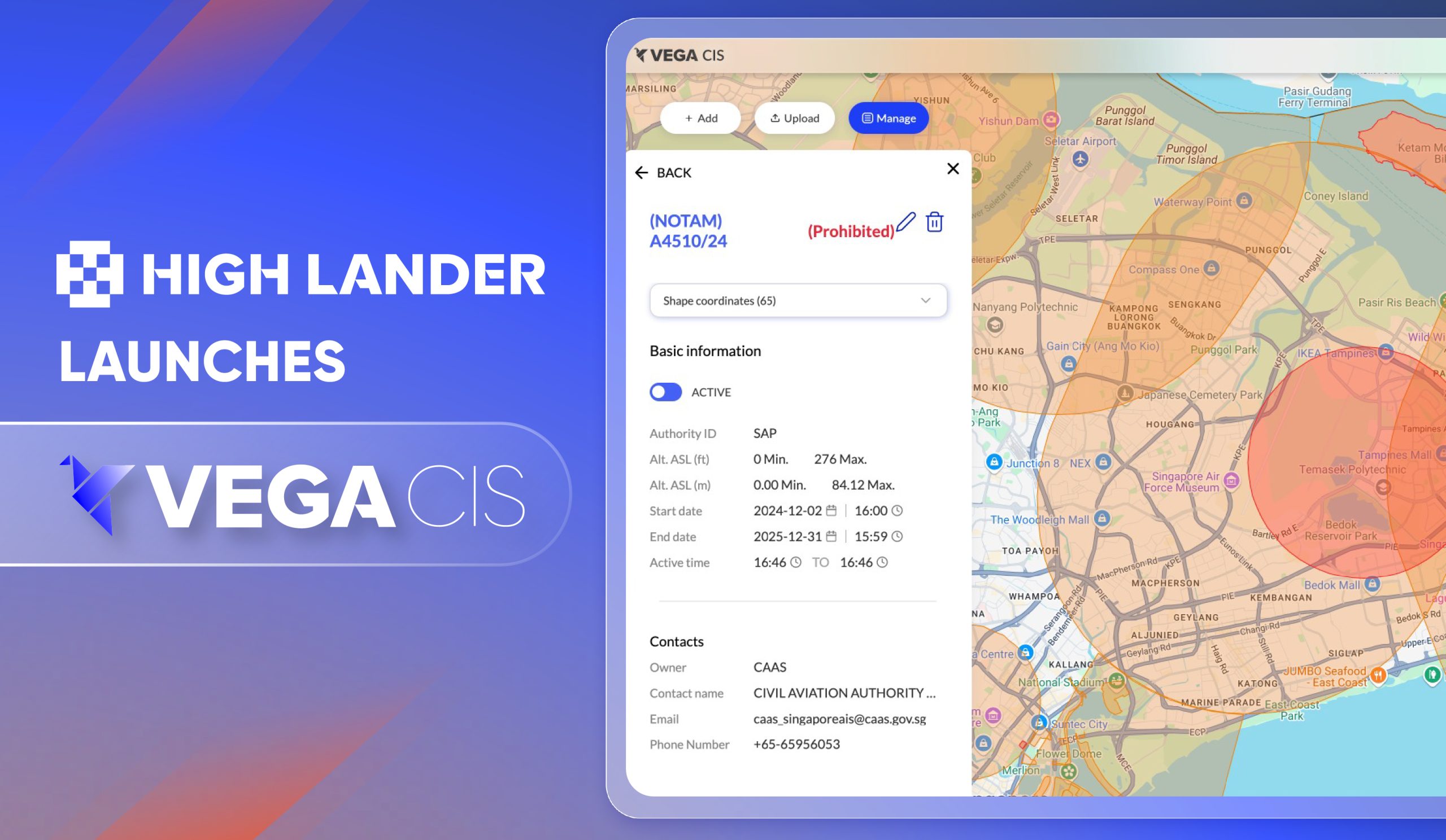
High Lander’s Vega CIS is a tool designed for airspace managers (i.e. ANSPs, air traffic management, aviation authorities) to create airspace constraints, perform Dynamic Airspace Reconfiguration (DAR), and share geo-awareness data in real time with UTM/USSP service providers and UAS operators. It’s operated via an intuitive desktop-based platform, while an associated mobile app provides airspace data to end-users.
The dashboard enables the creation of three types of airspace: info zones, where UAS flight plans are automatically approved in accordance with UTM-powered deconfliction and prioritization protocols; restricted zones, where authorities customize and authorize permissions; and prohibited zones, where UAS flight plans will be automatically denied. Airspace restrictions can be customized in granular detail according to variables including UAS size and class, mission details and regulatory approvals. Additionally, authorization can be granted manually if required.
The Vega CIS dashboard streamlines a complex process that until now had required considerable time, expertise and red tape to complete. The solution’s innovative NOTAM engine further saves time and effort by automatically converting coded text-based notices into visualized airspace constraints on the dashboard map.
Crucially, by enabling ecosystem-wide data synchronization both directly and via discovery and synchronization service (DSS), Vega CIS provides the basis for digital airspaces where UAS can operate at scale in safety, even when under the control of diverse operators and service providers.
Harmony in the skies
Currently, the safe coordination of airplanes and drones is the dream of the aviation industry. Vega CIS may just be the way we finally achieve this.
Vega CIS gives airspace managers ownership of dynamic UAS-enabled airspaces, and enables them to adjust UAS permissions in real-time according to air traffic control (ATC) data and flow. By putting the power to manage UAS permissions in the same hands that manage traditional air traffic, conflicts between the two generations of aircraft no longer need to be a problem.
“Large-scale UAS operations, including public safety drones, advanced air mobility networks and urban aerial delivery services, are not feasible in complex airspaces without dedicated digital infrastructure enabling ecosystem-wide coordination and regulatory oversight,” added Abelson. “High Lander is proud to answer the call and enable this exciting new era of aviation with Vega CIS.”
CIS, UTM, Fly: Come and experience the Vega Hub
Vega CIS joins the solutions of Vega Hub, comprising Vega UTM, High Lander’s proprietary UAS traffic management solution, and Vega Fly, a mobile app for drone operators to receive airspace data and flight plan authorization. Together, they provide an end-to-end suite of software solutions for the management of UAS traffic.
Meet the High Lander team at Stand 21230, where we will be showcasing live demonstrations of the Vega Hub and sharing our vision for the future of airspace management. Come discover how Vega CIS is shaping the next era of aviation — we look forward to welcoming you!